
Advisory
Potential for extended period of high surf, dangerous rip currents, and minor to moderate coastal flooding across south and southwest
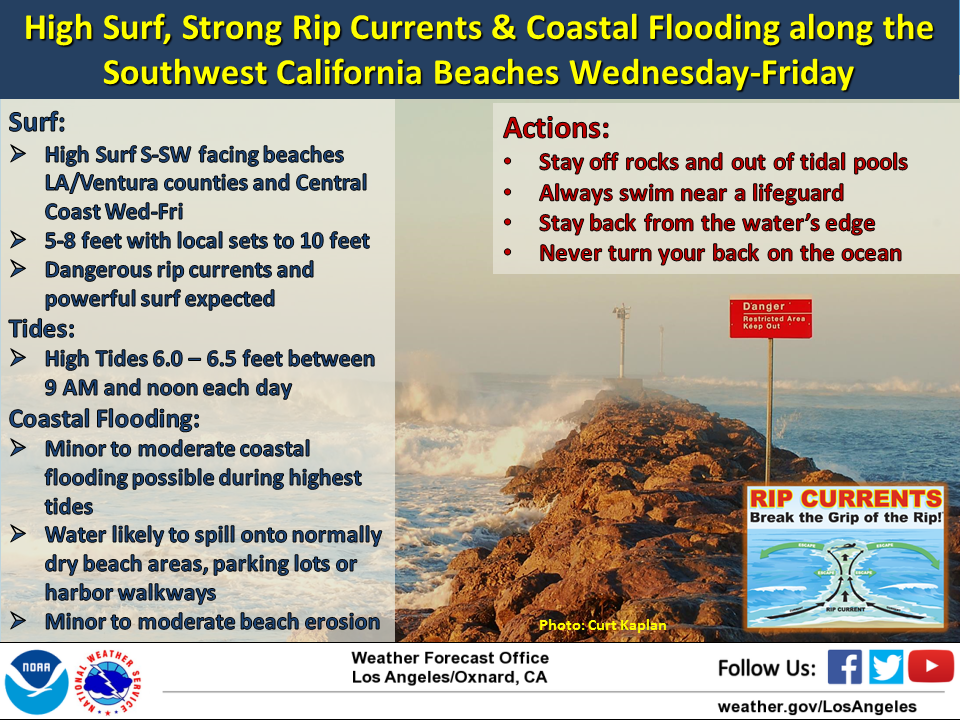
MAIN IMPACTS
FORECAST CONFIDENCE
SYNOPSIS
Hurricane Sergio, currently centered around 1400 miles southwest of Los Angeles,
is expected to track back to the northeast during the next few days, eventually weakening to a tropical storm and making landfall in central or northern Baja. While most of the moisture from this tropical system is expected to remain south and east of our forecast area, there is the potential for significant hazards in the beach zone later this week as Sergio tracks back into our surf window, bringing a return of large south-southwest swell into our area. The swell that originally brought high surf from Sergio on Friday was from a 170-180 degree direction, which favored the Long Beach area and resulted in some coastal flooding issues. The direction of this new swell energy From Sergio is expected to range between 190 and 210 degrees and is expected to be larger than Friday’s event. This direction favors the large surf to be focused across south and southwest facing beaches from Oxnard to Marina Del Rey, as well as the Central Coast (including Pismo Beach and Port San Luis). Minor coastal flooding issues will be likely near times of high tide for the above mentioned areas Wednesday through Friday, but is not expected to be as great a threat for the Long Beach area due to the change in direction of the swell energy.
Potential for extended period of high surf, dangerous rip currents, and minor to moderate coastal flooding across south and southwest 
...Potential for extended period of high surf, dangerous rip currents, and minor to moderate coastal flooding across south and southwest facing beaches Wednesday through Friday...
Details
- High Surf
- New long period swell energy (190 to 210 degrees) from Hurricane Sergio expected Wednesday through Friday.
- Building surf on Tuesday, with potential for extended period of high surf conditions Wednesday through Friday,
- Breakers of 5 to 8 feet with local sets to 10 feet possible on south and southwest facing beaches of Los Angeles and Ventura counties as well as the Central Coast.
- Coastal Flooding
- Minor to moderate coastal flooding possible across low-lying south and southwest facing beaches from Oxnard to Marina Del Rey (especially Malibu) as well as the Central Coast near times of high tide.
- Tide Information
- Santa Monica - Projected high tides of 6.0-6.5 feet between 9 am and 11 am Wednesday through Friday
- Port San Luis - Projected high tides of 5.7-6.1 feet between 930 am and 1130 am Wednesday through Friday
MAIN IMPACTS
- Sneaker waves inundating beaches and overtopping jetties
- Dangerous and frequent rip currents likely
- Minor to moderate coastal flooding and beach erosion possible near times of high tide across south and southwest facing beaches
- Water likely to spill onto normally dry beach areas, parking lots, or harbor walkways.
FORECAST CONFIDENCE
- Moderate confidence in extended period of high surf, strong rip currents, and potential coastal flooding across south and southwest facing beaches
SYNOPSIS
Hurricane Sergio, currently centered around 1400 miles southwest of Los Angeles,
is expected to track back to the northeast during the next few days, eventually weakening to a tropical storm and making landfall in central or northern Baja. While most of the moisture from this tropical system is expected to remain south and east of our forecast area, there is the potential for significant hazards in the beach zone later this week as Sergio tracks back into our surf window, bringing a return of large south-southwest swell into our area. The swell that originally brought high surf from Sergio on Friday was from a 170-180 degree direction, which favored the Long Beach area and resulted in some coastal flooding issues. The direction of this new swell energy From Sergio is expected to range between 190 and 210 degrees and is expected to be larger than Friday’s event. This direction favors the large surf to be focused across south and southwest facing beaches from Oxnard to Marina Del Rey, as well as the Central Coast (including Pismo Beach and Port San Luis). Minor coastal flooding issues will be likely near times of high tide for the above mentioned areas Wednesday through Friday, but is not expected to be as great a threat for the Long Beach area due to the change in direction of the swell energy.
Address/Location
Manhattan Beach Fire Department
400 15th St
Manhattan Beach, CA 90266
Contact
Emergency: 9-1-1
Non-emergencies: 310-802-5203